 eAtlas Data Catalogue
eReefs, Great Barrier Reef Foundation
Type of resources
Topics
Contact for the resource
Provided by
status
-
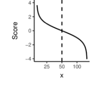
The dataset represents the code base developed for the generation of water quality metrics from various data sources (eReefs Biogeochemical models, MODIS Satellite imaging and AIMS in situ sampling). The water quality metric used underpinning previous Report Cards (until 2015) presented a number of significant shortcomings: - It was solely based on remote sensing-derived data. Concerns were raised about the appropriateness of exclusively relying on remote sensing to evaluate inshore water quality, considering well-documented challenges in obtaining accurate estimates from optically complex waters and the fact that only limited valid satellite observations are available in the wet season due to cloud cover; - It was limited to reporting on two indicators and did not incorporate other water quality data and indicators collected through the Marine Monitoring Program (MMP) and the Integrated Marine Observing System (IMOS); - It appeared relatively insensitive to large terrestrial inputs into the GBR lagoon during large rainfall and runoff events, most likely due to the binary assessment of compliance relative to the water quality guidelines and aggregation and averaging over large spatial and temporal scales; In 2016, based on the limitations described above, the Reef Plan Independent Science Panel (ISP) expressed a lack of confidence in the water quality metric that underpinned Report Cards (prior to 2015) and recommended that a new approach be identified for the Report Card 2016 and future Report Cards. The ISP also acknowledged substantial advancements in modelling water quality through the eReefs biogeochemical models and the fact that recent research and method development had improved our ability to construct report card metrics. Methods: - Index scoring strategies were systematically assessed to meet key objectives of sensitivity and representativeness, to allow data aggregation and to enable the integration of additional water quality measures when these become available in the future. A preferred method was identified as the scaled modified amplitude method with fixed caps sets at half and twice the threshold values, which was tested both theoretically and using historical datasets. - Aggregation strategies were reviewed and a hierarchical aggregation scheme was developed to allow multiple measures and sub-indicators to be combined into a single metric and to allow spatial and temporal aggregation. The process was designed to maintain the richness of information and allow the propagation of uncertainty, which were key project objectives. - The resulting water quality metric calculation process and parameters were applied to the development of the marine water quality metric component of Reef Report Card 2016, covering the reporting period 1 October 2015 to 30 September 2016. Format: The data are in the form of R code. Note, the code cannot be run as a standalone entity as it relies on non-public input data sources.